


")


by Arjun Walia
January 19, 2016
from Collective-Evolution Website
Advanced ancient civilizations are a big topic of interest among researchers, historians, archaeologists, and scientists.
Every single year we are gifted with a mysterious find that has us questioning the origins of the human race and imagining the cultures which roamed the earth before us. We have found much evidence to suggest that there may have been civilizations in existence before us which were intellectually, and even technologically superior.
That being said, this theory is still thought to be quite fantastical; despite all of the evidence which has been brought to light in recent years to support this notion, it is still largely ignored by the mainstream.
If you are interested in looking at some of this evidence, a great place to start is with author Graham Hancock, in his book titled The Magicians of The Gods.
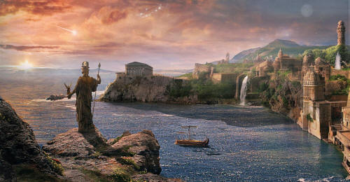
Atlantis
If you start talking about the lost, ancient city of Atlantis, most people will probably think that you’re living in ‘la la’ land.
Many people are unaware that this city has been seriously studied for hundreds of years.
For example, we can see that it was a subject of significant importance for researchers at the Smithsonian Institution, as emphasized by their Annual Report of the Board of Regents of The Smithsonian Institution for the year ending June 30th, 1915.
In the report, author M. Pierre Termeir, a member of the Academy of Sciences and Director of Service of the Geologic Chart of France, gives a lecture regarding the Atlantean civilization.
He makes a compelling case for further study of this lost city:
After a long period of disdainful indifference, observe how in the last few years science is returning to the study of Atlantis.
How many naturalists, geologists, zoologists, or botanists are asking one another today whether Plato has not transmitted to us, with slight amplification, a page from the actual history of mankind.
No affirmation is yet permissible; but it seems more and more evident that a vast region, continental or made up of great islands, has collapsed west of the Pillars of Hercules, otherwise called the Straight of Gibraltar, and that its collapse occurred in the not far distant past.
In any event, the question of Atlantis is placed anew before men of science; and since I do not believe that it can ever be solved without the aid of oceanography, I have thought it natural to discuss it here, in this temple of maritime science, and to call to such a problem, long scorned but now being revived, the attention of oceanographers, as well as the attention of those who, though immersed in the tumult of cities, lend an ear to the distant murmur of the sea.
You can read this full report here, starting on page 219.
In his lecture, M. Termeir goes on to present zoologic, geographic, and geologic data to support the existence of the lost Atlantean civilization. Not only that, archaeological discoveries on the ocean floor have also raised some questions
Not only that, archaeological discoveries on the ocean floor within the past decades have also raised some questions…
Plato’s Description of Atlantis
Plato, the ancient Greek philosopher, provides a description of Atlantis in his dialogue Critias, which was never completed.
The following is a summary of his depiction, these are a few of many points I am taking from Manly P. Halls, The Secret Teachings of All Ages
- Atlantis was inhabited by ‘earth-born’ and ‘primitive’ human beings. One of them was wooed by the god Poseidon, who interbred with the human beings, and they eventually bore five children. This interbreeding between gods and humans is a common theme in many historical texts found throughout the world.
- The land was divided into concentric zones of land and water. Two zones of land and three zones of water surrounded the central island, which had warm springs of water and cold springs of water.
- Atlantis became an established country, with a wise government and an industry that sprung them to advanced technological heights – beyond even what we have reached today.
- Atlantis had limitless resources, wild animals, and precious metals, and was heavily populated.
- Atlantis was full of large and beautiful palaces, temples, docks, and a network of various bridges and canals that united different sections of the kingdom.
- White, black and red stones were used in the construction of public buildings.
“They circumscribed each of the land zones with a wall, the outer wall being covered with brass, the middle with tin, and the inner, which encompassed the citadel, withorichalc.
The citadel, on the central island, contained the palaces, temples, and other public buildings. In its center, surrounded by a wall of gold, was a sanctuary dedicated to Cleito and Poseidon.”
- Atlantis had a number of gardens, full of hot and cold springs. There were countless temples, public baths, and exercise facilities for both man and animal.
- The part of Atlantis,
“facing the sea was described as lofty and precipitous, but about the central city was a plain sheltered by mountains renowned for their size, number, and beauty.
The plain yielded two crops each year, in the winter being watered by rains and in the summer by immense irrigation canals, which were also used for transportation.
The plain was divided into sections and in time of war each section supplied its quota of fighting men and chariots.”
- Atlantis was massive, ruled by multiple kings who all had control over their land. Their relationships with the other kings were governed by an original code of ethics that was engraved by the first ten kings.
“The chief laws of the Atlantean kings were that they should not take up arms against each other and that they should come to the assistance of any of their number who was attacked.”
The Downfall of Atlantis
These are the essential points Plato makes about Atlantis.
He described it as a great and powerful empire, almost magical, and said that this was the same empire which attacked the Hellenic states.
He attributes the power and glory they tasted after this venture to their eventual demise, writing that the love for these ego-driven desires that soon developed among Atlantean kings “lured” them from “the pathway of wisdom and virtue.”
“Filled with false ambition, the rulers of Atlantis determined to conquer the gods into his holy habitation and addressed them. Here Plato’s narrative comes to an abrupt end, for the
Critiaswas never finished.”
Plato also tackles the subject of Atlantis in his Timaeus, writing of a story told by Solon – who himself is said to have heard the story in Egypt, passed on to him by a priest via hieroglyphic inscriptions in a temple in Sais – in which a violent cataclysm sank the continent.
Thus, the Island of Atlantis completely disappeared. (source)
“A technologically sophisticated but morally bankrupt evil empire – Atlantis – attempts world domination by force. he only thing standing it its way is a relatively small group of spiritually pure, morally principled and incorruptible people – the ancient Athenians.
Overcoming overwhelming odds…the Athenians are able to defeat their far more powerful adversary simply through the force of their spirit. Sound familiar?
Plato’s Atlantean dialogues are essentially an ancient greek version of ‘Star Wars’.”
Ken Feder,
professor of archaeology,
“Frauds, Myths and Mysteries: Science and Pseudoscience in Archaeology.”
The Egyptian connection is also interesting to bring up here because Crantor, another ancient Greek philosopher, asserted that the Egyptian priests declared the story of Atlantis to be written upon pillars which were still preserved circa 300 B.C.
Manly P Hall has noted that, before this cataclysm, a portion of the population left and did not succumb to the egoistic tendencies which apparently led to downfall of Atlantis.
Was the philosophic, religious, and scientific knowledge of Atlantis passed on? There are many similarities between the reported teachings of Atlantis and those of other cultures, such as the Mayas of Central America.
According to Manly P. Hall, from the Atlanteans,
“the world received not only the heritage of arts and crafts, philosophies, and sciences, ethics and religions, but also the heritage of hate, strife, and perversion.
The Atlanteans instigated the first war; and it has been said that all subsequent wars were fought in a fruitless effort to justify the first one and right the wrong which it caused.”
“Before Atlantis sank, its spiritually illuminated Initiates, who realized that their land was doomed because it had departed from the Path of Light, withdrew from the ill fated continent.
Carrying with them the sacred and secret doctrine, these Atlanteans established themselves in Egypt, where they became its first divine rulers.
Nearly all the great cosmologic myths forming the foundation of the various sacred books of the world are based upon the Atlantean Mystery Rituals.”
(
One of the most interesting parts of this story, to me, is the fact that this place is often remembered as a place of glory, light, and abundance, which it was.
But they were not immune to the dangers of avarice, either, as H.P. Blavatsky makes clear:
“Under the evil insinuations of their demon,Thevatat, the Atlantis race became a nation of wickedmagicians.
In consequence of this, war was declared, the story of which would be too long to narrate; its substance may be found in the disfigured allegories of the race of Cain, the giants, and that of Noah and his righteous family.
The conflict came to an end by the submersion of the Atlantis, which finds its imitation in the stories of the Babylonian and Mosaic flood.”
(
source– Part II)
Manly P Hall
‘Atlantis and the Gods of Antiquity’
by Joseph P. Skipper
July 12, 2010
from MarsAnomalyResearch Website
The report is about an Earth based scenario, a combination of the possibilities inherent in a background Earth story, some possible hypotheses by me, and then some visual evidence to add into the mix. It will be up to you to decide if there is any merit.
First we’ll start with the background story.
In more modern times, the story of ancient Atlantis has fascinated generations and some to obsession as a real place. As many of you may know, it is acknowledged that the story of Atlantis was first introduced into public awareness via dialogues by the Greek philosopher Plato around 355–360 BC.
As the story goes, Plato’s references regarding Atlantis was allegedly in turn sourced from a 500 hundred years earlier 6th century BC trip by the Athenian lawgiver Solon to Egypt where an Egyptian priest there translated a part of an unknown history of ancient Athens and Atlantis from papyri scrolls of Egyptian hieroglyphs to Greek of a time some 9,000 year earlier to that 6th century period.
According to the translation, it seems that the god/man Poseidon (you know, Zeus, Hera, Apollo etc.) fell in love with a human female named Cleito on the island Atlantis who bore him many sons, the oldest of which was named Atlas. Now it should be noted at this point that the term “Atlantis” in Greek means “island of Atlas” and the term “Atlantic” Ocean was named after Atlas.
It seems that in the even more distant past, the “gods” divided up Earth lands among themselves and Poseidon to his liking was assigned the then Atlantis lands west off of the Pillars of Hercules which the latter we know today as the Strait of Gibraltar separating the Atlantic Ocean and the Mediterranean Sea.
So, despite the many other location prospects presented by others as more likely sites, the ancient story clearly places the location of the Atlantean culture in the Atlantic Ocean somewhere west of the Strait of Gibraltar.
Many have a problem with this because it is the scientific consensus opinion that this location is geologically impossible. Further, since science now days considers itself rational and enlightened, the story starting off with the “god” Poseidon likely causes many not to take it serious and regard it as little more than fabricated myth.
However, this ignores the ancient Sumerian and Indian culture record as also referring to such “gods” in human formincluding conducting great wars with each other.
The consensus also makes the assumption that such records are not history but merely fabricated myths and legends to explain events they didn’t understand by ancient people less sophisticated and knowledgeable than ourselves. In my opinion, such views reveal more about our flaws and arrogance than ancient ones.
In any case, the story goes on to describe Atlantis as an island or a great number of islands occupying a very large area of specific measurement so that it might also be considered as large as a continent. Therefore do note that it isn’t described so much as a “continent” as we think of single land mass but a collection of land masses with the island Atlantis as its center of power.
The Atlantean’s are described as a naval power that also possessed flying machines. It seems that landmass Atlantis itself was occupied by Atlas and was an island with mountains.
One of these mountains where Cleito apparently resided was carved by Poseidon into a great palace with concentric rings of land, walls, and canals extending out from its center and complete with other canal systems. It seems that the eastern most and other reaches of the Atlantean world were separate kingdoms divided up almost certainly among Atlas’s brothers and so the Atlantean world was a confederation of kingdoms with Atlantis as its power center.
In the time some 9,000 years before the time of Solon and the translation, the Atlantean confederation or some portion of it was apparently aggressively attacking and conquering in western Europe, parts of Africa, and attacking into the Mediterranean where they encountered ancient Athens. Athens standing alone stopped them militarily and thus no doubt the reason for Solon’s Greek interest in the Egyptian translated story.
At some point in time not too long after this Atlantean military defeat there is suppose to have been some kind of earthquake upheaval that in one day and night caused the whole of the Atlantean world to sink beneath the Atlantic Ocean causing mud to poor in on top of it creating an impassable and unsearchable muddy shoal and a hazard to navigation.
Remember such records in these ancient times were likely one-off laboriously hand inscribed accounts and not a record that is repeated as we do today via books and electronic devices.
So if the one record is destroyed, the account is lost forever. So this is a no doubt condensed Egyptian account/record further condensed by Solon, further condensed by Plato, and further condensed and interpreted by people like me in more recent times so that much information and, more important, a true sense of elapsed time is lost and/or distorted.
So there may be a tendency to think about this account happening in shorter lengths of condensed time than may have actually been the case.
For example, we now know something about plate tectonics as well as continental drift and we now know, if we thought about it very much, that this identified location out in the Atlantic west of the Pillars of Hercules would be near an ever expanding seam between tectonic plates and a geologically unstable area due to that fact. This suggests the multiple fracture zones of the Mid-Atlantic Ridge.
Logically, over the centuries earthquakes and rising sea levels may have alerted many intelligent advanced Atlantean people to their island life peril and especially among the island kingdoms with lower elevations.
This would have likely caused some Atlanteans, especially in the Atlantean eastern reaches, to be concerned about future sudden flooding caused by earthquakes building in intensity over the years and/or centuries and flooding shorelines. That may have caused them to attempt to shift populations further eastward to the mainland of western Europe and Africa getting into conflict with those already there occupying those places.
Also, before I forget to include this, it should be noted at this point that the Egyptian account clearly identifies a continent further west of Atlantis bounding the Atlantic Ocean that sounds an awful lot like the American continents. This in turn clearly suggests at least an Egyptian familiarity in ancient 6th century BC times and/or before with the western boundaries of the Atlantic Ocean and its navigation.
That would make sense with a broad area of islands in the mid Atlantic making island hopping or circumventing navigation westward to the Americas much easier.
There is even the information in the account of the sunken shoals of Atlantis impeding navigation in the Atlantic.
Even if the Egyptian account is false and a creation by Plato or his predecessors, it still suggests a navigation knowledge of the Atlantic Ocean to its western boundaries by some Mediterranean people in 355-360 BC and/or before Plato’s time and that too is significant.
Also, here’s another consideration. The underwater terrain area immediately east of the Mid-Atlantic Ridge area has not only many fracture zones demonstrating geological instability but many mountain ranges as well no doubt created over time by that geological instability. Some of the highest mountains stick out of the water and their tops are islands out in the mid Atlantic. It is also likely that the highest mountains would be those created deeper within the Mid-Atlantic Ridge fracture zone areas.
Now consider that the events described here allegedly happened roughly about 12,000 years back into the past from the present time. Today our science tells us that the last glacial maximum (coldest period) peaked about 20,000 years ago and ended about 10,000 years ago as we entered the current interglacial cycle warming period.
That means that 12,000 year ago from our time the Atlantean culture would be facing a warming trend that would have been ongoing and well along for some 8,000 years with melting ice sheets and sea levels rising nearing to the completion of this warming cycle just 2,000 years in their future.
Think about it. Depending on its possible age of existence, the Atlantean culture may have been initially established at some period during the last ice age glacial maximum around 20,000 years ago. During that earlier time, the ice sheets would likely have been at their peaks of mass and the sea level would have been at its lowest.
That means that a great deal of the top of those mountain ranges east of the Mid-Atlantic Ridge plate tectonic seam would have likely been sticking considerably out of the water forming a massive area of islands with many of them land interconnected and suitable for habitation.
This has all kinds of negative implications for any civilization based on the mountain range islands in the mid Atlantic during an 8,000 year long to that date interglacial warming/melt trend and its geological changes.
As their island centers were threatened by rising water levels and increasingly made more and more vulnerable to the occasional earthquake driven tsunamis and other rogue waves from deeper water over the centuries, there would have logically been a migration from this home area by many while others stayed behind unwilling to leave so typical of human behavior. This would explain the view of Atlanteans moving east by Egyptian and Greeks as invaders.
Did you know that Egyptian earliest history includes accounts of battles fought with unidentified peoples from the west?
The Atlanteans on the move, but being a finite number of people without the replenishment reserves of an long term established people and even with more advanced technology, they would gradually have been worn down in conquering ability pushing east into western Europe and Africa until finally exhausted they met their match and perhaps were stopped by the Athenians and a growing culture that later produced the fiercely committed Spartan defenders at Thermopylae.
If so, now all that is left of their legacy is perhaps some of their DNA in many of us and some long lasting megalithic structure evidence in Europe and Africa as their smaller numbers were eventually absorbed into the greater human whole of that part of the world.
This is the Earth Atlantis story in basic and some of my thoughts on it. You will notice that I do not label this information as so many others do as myth. From my point of view, it is neither myth nor truth but simply a story like that of Troy that may have some basis for fact in it and not to be summarily dismissed.
In other words, I suspect there is core truth to be had somewhere in this story.
You can perhaps understand that, when I got Google Earth, one of the first things I did was go looking for any sign of civilization underwater in the Atlantic west off of the Pillars of Hercules where the Atlantean culture at its height is alleged to be located. I expected nothing and especially not in light of the fact that so much of the satellite imaging has been obfuscated.
However, I did find what clearly appears to be some evidence of artificial construction underwater west southwest well out from the Strait of Gibraltar.
I was going to report on it before now but got distracted into planetary evidence and kept putting it off until now. I also delayed because I wanted to further inspect what appears to be some underwater canal systems joining certain islands still sticking out of the water in the general area.
However, recently I received an email bringing this site back to my attention from a Clinical Psychologist Dr. Christof Lehmann wanting to know what I thought of the same underwater formations. I’m glad he did.
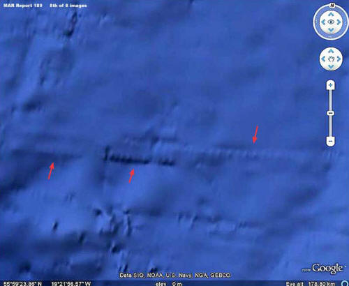
Now let’s look at some Google imaging showing the location of the site and the site itself.
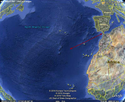
The above 1st image is a context view showing the Atlantic Ocean, the position of the unstable Mid-Atlantic Ridge tectonic plate fracture zone and the rough mountainous underwater terrain produced by it.
Likewise, the red arrow demonstrates the underwater evidence site to the left relative to the Strait of Gibraltar or Pillars of Hercules to the right at the mouth of the Mediterranean.
As you can see, the placement of the site is in general consistent with the ancient story of the placement of the Atlantean empire.
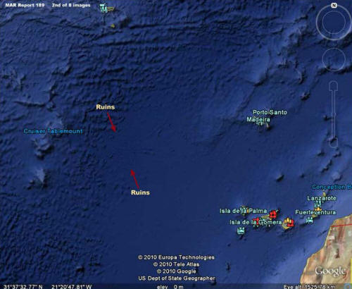
The above 2nd image from Google Earth provides a closer but still context view showing a little more detail of the evidence that surrounds the site.
Note that the site in question appears to be underwater on the east edge of the rough mountainous Mid Atlantic Ridge terrain and on the west edge of a more level plain. However, one needs to be cautious. This may or may not be accurate as a portion of the smoother plain appearance may also be the result of smudge treatments applied to the local area.
In fact, if one takes into consideration image tampering treatments, what we can see of the underwater ruins may merely be only part of a greater whole hidden by smudge treatments.
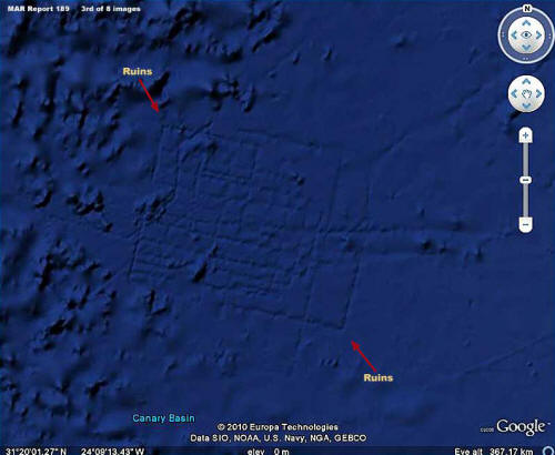
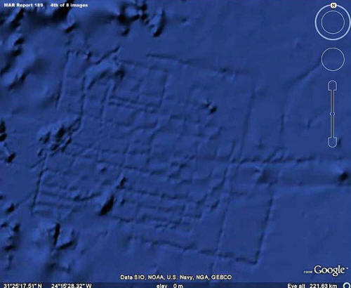
The above 3rd and 4th images provide different types of views of the underwater ruins site.
As you can see these many geometric right angle and linear lines are almost certainly represent artificially created ruins of some kind. However, note that there are apparently no concentric round rings as the story describes that are suppose to be on the main island of Atlantis. Further, while there are other long linear lines east of this site that could be old ancient canals connecting islands, there is no more evidence of ruins this definitive in the immediate surroundings.
Does this tell us that this isn’t Atlantis? Not hardly.
The ruin outlines you see above are also how this site would look if smudge image tampering were a factor. Same with the extensive smooth plain to the east of this site. You can take nothing for granted in this regard as to what role image tampering may play by hiding evidence.
So does this tell us that this is Atlantis? Again the answer is no.
However, what it does tell us is that what we have here is artificial ruin outlines underwater on the bottom of the Atlantic Ocean where none should exist and that alone is very significant. Scientists tell us that this is impossible but here you have the visual evidence.
Unless some advanced aliens built something here underwater that has been covered over by smudge treatments and still printing through them, we’re almost certainly looking at ancient human civilization construction evidence that had to have been created by ancients over time and unquestionably out of water. That means that this site existed at one time in the past out of water and on dry land.
That in turn logically means that this civilization evidence may have existed active at some time during the last glacial cold period as much as 20,000 years ago when the ice sheets were at their maximum and the water level here was much lower than now exposing these lands to air and sunlight.
That in turn makes the story of some ancient civilization like the Atlantean culture in the Atlantic Ocean off of the Pillars of Hercules more feasible.
For example, the destruction of Atlantis, if the overnight time frame is legitimate and not a result of condensing the time line in the Egyptian reporting the event, may have been the result of a combination of things building up over centuries. Rising water during the interglacial warming trend would be the chief suspect but would not alone sufficiently explain the overnight disaster scenario.
On the other hand, warming trend rising water levels would have made islands more vulnerable to inundation at the same time that increasing downward weight pressure of the rising water on the Mid-Atlantic Ridge geologically unstable area could have created a subterranean collapse of the plate dropping down a bit and/or a significant earthquake displacing and pushing water in a great wave over the already vulnerable island culture depositing swirling stirred up bottom sediment (mud) over the area.
The above evidence site may or may not be part of an Atlantean empire.
However, it was a part of something out here in this now underwater terrain and there is no telling what extensive civilization evidence may be hidden in this area under smudge treatments. If there is anyone out there around the world with access to commercial satellite imaging of this underwater general area that may not have been subjected to tampering treatments, please get it to me for examination and we’ll see if there is anything more to be seen here!
Now that the above evidence leans so much in favor of artificial civilization evidence being possible underwater in this general area of the Atlantic Ocean, is there is further evidence of the civilization kind on this side of the Atlantic?
As it turns out, there actually is north of this area and off the west coast of Ireland and the visual evidence is as follows.
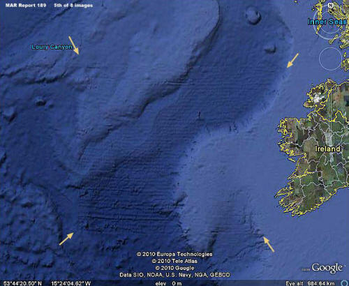
The above 5th image is the wide angle context view of that evidence both out on the coastal shallower water shelf represented by the lighter blue color and down in a deeper canyon system represented by the darker blue color.
Note that this evidence is not really like the ruins of buildings because the imprint of it is finer and closer textured but still with the sharp 90º right angle boundary geometry and long straight linear lines so typical of man’s constructions.
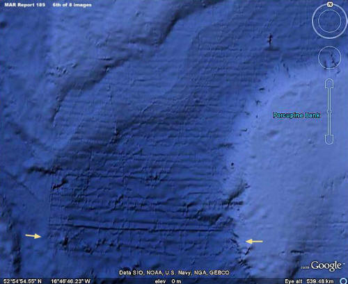
In the above 6th image, note the lower section pointed out between the two arrows.
This looks suspiciously like writing of some unknown kind, at least to me. IF this is writing, perhaps some better forensic imaging experts in conjunction with some linguist experts probably in ancient text could get better details and interpret this?
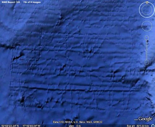
To that end, the above 7th image provides a closer view of this possible writing.
It also provides a good view of how precise the southern straight line boundary of this grid like site makes a perfect sharp 90º turn upward north forming the west boundary edge of the entire site. As you can see, the corner is just too right angle perfect to be the result of some natural occurrence and has been almost certainly implemented by artificial means.
As with the previous evidence, the presence of smudge and/or a mud covering on the site tells us that these are not imaging artifacts but something actually present on the bottom.
The above 8th image view is of the top or north and west boundary of the site off of Ireland.
As you can see, this area of the site is more compromised by blur. That is caused I suspect mostly by obscuring smudge treatments but acknowledge that it could be mud as well. However, even so, note there are many objects (containers ?) of the same size and in a side-by-side east/west orientation repeating in a long uniformly even line here mostly but not completely obscured and as pointed out by the red arrows.
It obviously suggests artificiality rather than something of natural origin. What any explorer worth his salt wouldn’t give to go down and inspect that long line of same size objects seen in the above 8th image!
What this site is exactly I cannot say. Could it be a giant horizontal read message board with all the main smaller text obscured and only the grossly large bottom line of text printing through the obscuring mud and/or smudge?
What ever it is, the main thing is that it appears to be of artificial origin and it is underwater in the Atlantic off the west coast of Ireland. It is entirely possible that this site also dates back into glacial maximum times when the water levels here were at their lowest level exposing this area to the air and sunlight enabling this construction.
The problem with that consideration is that 20,000 years ago during the peak glacial cold cycle, the ice sheets extending down from the Artic north of this point would likely have covered this site making it very difficult for human habitation. Also, the lowered sea levels would have exposed what is now the British Isles including Ireland and the English Channel making this area a landmass extension of the European continent.
If this now underwater site would not be conducive to human habitation back then during the glacial cold cycle,
- Could this site be some kind of giant heated grid type sign system then on exposed land melting ice away from around it and framing a giant message meant only to be seen from above?
- Perhaps a giant boundary marker defining territory?
In other words, discoveries raising questions like this point to a time in this planet’s history when things were happening that we in our ignorance in this time have little to no knowledge of today except for a few privy to truthful satellite imaging.
With that in mind and consistent with human behavior, there may be a tendency to speculate that these things were happening before our recorded history? If so, let me say a word about that.
More than likely, there was such a recorded history.
For example, the ancient libraries that we know were intentionally sacked and burned a number of times in the lands around the Mediterranean may have contained a great deal of this information. So much of the information in them was destroyed just because of the information they contained that someone of the time didn’t want known.
So, with the destruction, the information lost to human civilization is incalculable. I might add that sadly much of that library destruction was undertaken in the name of religion and its intolerance for difference.
I am reminded of the ancient peoples in the opposite direction of South and Central America.
They recorded a great deal of history on gold likely thinking that the knowledge would never perish on this wonderfully stable metal. They did not of course anticipate that European white men driven by greed and accompanied by zealot guardians of religion would wish to destroy even history, covet the gold, melt it down wholesale (again knowledge destroyed) too fill great ship convoys headed back to Europe to feed even greater greed and the power addicts of that time.
If very much of any of this ancient information had survived intact, it is possible that humanity would have surged centuries ahead increasingly on an individual basis not nearly as dependent on leaders to manipulate us via spin telling us what to think, how to feel, and what to do that always seems to benefit the few but rarely the many that take the action and run the risks.
However, that’s just my personal thoughts.
Addendum added 7/19/2010
It has been brought to my attention by a number of people that this possible site in the Atlantic off of the Pillars of Hercules has been discovered and apparently reported on previously by someone else also making a possible Atlantis connection. I don’t know who.
At the same time it seems that Google has put forth an official explanation found HERE that the evidence is a artifact of bathymetric data collection sonar process from boats with the lines reflecting the path of the boats. I was not aware either of the prior discovery or the official explanation at the time of my reporting above.
Because of the location of this particular evidence, it is natural to associate this site with Atlantis.
The subject of a technologically advanced human civilization prior to our current recorded history is not welcome in science or political consensus circles just as it was not in ancient times with the destruction of the great libraries. In this time it is preferred to promote surprisingly advanced but still suitably and safely primitive cultures like the Minoans in the Mediterranean as the bases for the story of Atlantis.
As for the official Google explanation, if the Google Earth underwater search function revealed a pattern of sites like this as a result of fuzzy sonar readings around the Earth, such an official explanation might hold a little interest for more investigation.
However, no matter what they say, the evidence just isn’t there.
That means that the official explanation amounts to no more than a claim and it is clear that this site west off the Pillars of Hercules has been specifically targeted for this special explanation.
The bottom line is that, if they can get the deep rough and very intricate Mid-Atlantic Ridge massive area bottom information west adjacent to this site correct without such visual defects, that says it all and the official explanation is not something to take seriously. You must decide what has merit and what does not for yourself.
As for me, I stand by my reporting.
CHAPTER VI
ATLANTIS
ATLANTIS has enjoyed only a legendary history up to within a few years.
Research and archaeological discoveries have, however, put her into the class that has a written history, vague it is true at present, at the same time beyond controversy. Every day something new is brought to light about Atlantis. Quite recently records have come to hand proving conclusively that Atlantis is not a myth.
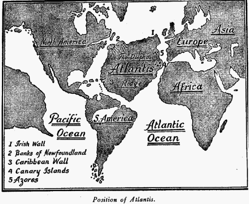
Atlantis was a large continent island situated in the North Atlantic Ocean with North and Central America to the west and Europe and northwest Africa to the east. Atlantis was in existence up to within a few thousand years ago.
Much light has been thrown on this great and important land of past history by the indefatigable work of Schliemann, to whom is due the honor for finally clinching the fact that Atlantis did once exist Plato 400 B. C. relates that Solon said!
“Atlantis was the center of civilization and conquered the whole world.
The most famous of all Athenian exploits was to overthrow the Island of Atlantis. This was a continent lying over against the Pillars of Hercules (Strait of Gibraltar) greater in extent than Libya and Asia Minor put together and was the passageway to other islands and a continent beyond of which the Mediterranean was only the harbor within the Pillars.
The Empire of Atlantis reached to Egypt and to Tyrrhenia. This mighty power arrayed itself against Egypt and the Hellenes and all the countries bordering on the Mediterranean Sea.
Then did Athens bravely, for, at the peril of her own existence and when the other Hellenes had deserted her, she repelled the invader and of her own accord gave liberty to all the nations within the Pillars.
A little while afterwards there was a great earthquake and the island itself disappeared in the sea.
“Poseidon was the founder of Atlantis. A temple was erected to Poseidon. There the people gathered every fifth and sixth year and with sacrifice of bulls swore to observe the Sacred Inscriptions which were carved on the Pillars of the Temple.”
Plutarch in his “Life of Solon” says:
“When Solon visited Egypt (600 B.C.) Souchis, a priest of Sais, and Psenophis, a priest of Heliopolis, told him that 9000 years before the relations of the Egyptians with The Lands of the West had been interrupted because of the mud which had made the sea impassable after the destruction of Atlantis and the country beyond by cataclysms and floods.”
Solon visited Egypt in 600 B.C. Atlantis sank 9000 years before. Add A.D. 2000 plus 9000 plus 600.
According to this record Atlantis sank 11,500 years ago, but I shall hereafter show that she did not sink to her present level for a long, long time afterwards. I found in an old Greek record that when Atlantis disappeared there were 3000 Athenian soldiers on her, probably an army of occupation. An Egyptian papyrus states that Poseidon was the first king of Atlantis and that he was followed by a long line of Poseidons, thus forming a Poseidon Dynasty.
The crown of Poseidon is shown as having three points, the numeral of the Motherland. His scepter was a trident, again showing Mu to be suzerain. The trident was the form of the Uighur scepter 20,000 years ago and later we find it as the scepter of the Khimers of Cambodia.
Le Plongeon found inscriptions in Yucatan stating:
“The first settlers in Atlantis were a company of Mayas from Mayax,” also, “Atlantis was first torn to pieces by earthquakes and then submerged.”
In this respect Atlantis’ fate was a duplication of the fate of Mu.
According to Dr. Henry Schliemann of ancient Troy fame:
“In the Museum at St. Petersburg, Russia, there is a papyrus roll, one of the oldest known. It was written in the reign of Pharaoh Sent of the Second Dynasty. The papyrus relates that: ‘Pharaoh Sent sent out an expedition to the west in search of traces of the Land of Atlantis from whence, 3350 years before, the ancestors of the Egyptians arrived carrying with themselves all of the wisdom of their native land. The expedition returned after five years with the report that they had found neither people nor objects which could give them a clue to the vanished land.’
“Another papyrus in the same Museum by Manetho, the Egyptian priest-historian, gives a reference of a period of 13,900 years as the reign of the Sages (Kings) of Atlantis. This papyrus places the height of the civilization of Atlantis at the very beginning of Egyptian history, approximately 16,000 years ago.”
The Sages referred to in this papyrus were the Kings of Atlantis. They reigned 13,900 years. Atlantis disappeared 11,500 years ago. Therefore, Atlantis was governed by a king 25,400 years ago, that is, Atlantis was a kingdom 25,400 years ago.
Dr. Schliemann made some wonderful discoveries about Atlantis which have been published by his grandson Dr. Paul Schliemann:
“When in 1873 I made the excavation of the ruins of Troy at Hissarlik and discovered in the second city the famous treasures of Priam, I found among that treasure a peculiar bronze vase of great size. Within it were several pieces of pottery, various small images of peculiar metal, and objects made of fossilized bone.
Some of these objects and the bronze were engraved in Phoenician hieroglyphics with a sentence which reads:
‘From the King Ckronos of Atlantis/One of the objects among the treasures of Priam is a vase with a peculiar owl’s head upon it (see Plate VI).
“Among a collection of objects from Tiahuanaco, South America, in the Louvre in Paris is another vase identically the same as I found among the treasures of Priam. It is beyond the range of coincidence for two articles in such widely separated areas as South America and Troy to make two vases of the same shape, the same size, and with curious owl’s heads arranged in just the same way.”
Another article from the treasures of Priam is a bird sphinx engraved:
“From the King Chronos of Atlantis.”
To my mind, there is no question as to what and to whom this bird sphinx refers.
It shows the connection between Atlantis and Mayax. It is an ornament, probably from a piece of statuary in Mayax erected to the memory of Queen Moo. Queen Moo’s totem was a macaw. This sphinx has the body of a leopard and the head of a macaw. A sphinx statue was erected in Mayax to Queen Moo’s brother husband, Prince Coh. Prince Coh’s totem was a leopard. Prince Coh’s piece of statuary was a dying leopard and is now in the National Museum, Mexico City.
Dr. Henry Schliemann found an inscription on the Lion Gate, Maycarne, Crete, which relates:
“The Egyptians descended from Misor. Misor was the child of Thoth, the god of history. Thoth was the emigrated son of a priest of Atlantis, who having fallen in love with the daughter of King Chronos, escaped, and after many wanderings landed in Egypt. He built the first temple at Sais and there taught the wisdom of his native land.”
This clears up two points in history:
- 1st, who the first people of Lower Egypt were
- 2nd, Thoth was not mythical but once a living man
The Troano MS. states that the first colonists who settled on the delta of the Nile were Mayas. As the people came from Atlantis and were Mayas, it shows that at least a part of Atlantis was peopled by Mayas.
Orpheus, a Greek, philosopher, wrote:
“In Chaldea the twin sister of Egypt, daughter of Poseidon, King of the lands beyond the sea and Libya.”
Some writers have confused in this sentence “lands beyond the sea” with “The Lands of the West” and from this assumed that Atlantis was Mu, the Motherland. I will correct this error before proceeding further. First I will quote what the priests of Egypt told Solon:
“9000 years before, the relations of the Egyptians with The Land of the West had been interrupted because of the mud that had made the sea impassable since the destruction of Atlantis; i. e., ‘the lands beyond the sea.’ “
In one of the Oriental temples there is a long history of Atlantis written 20,000 years ago.
I will now stop quoting old Greek and Maya and Egyptian records about Atlantis and give what no one else seems inclined to do – the geological tale of Atlantis which I think is as convincing as any written records.
THE GEOLOGICAL TALE OF ATLANTIS
I will first take you to one of the most inaccessible valleys in Central Asia. In this valley springs one of the headwaters of the Brahmaputra River.
On a large spur from the main range of mountains there is a large secluded monastery. In this monastery there are a great number of very ancient tablets of clay. These tablets have been divided into sections, one of them being on geology and history, going back to the time before the foot of man trod the earth. They have an extended history of Atlantis with a queer map on a tablet about two feet square.
The map shows Atlantis with the contour of the lands around the Atlantic Ocean which are vastly different from today.
I will quote what struck me as being remarkable:
“Atlantis was not always an island. In the days that have gone, before man appeared on earth and great monsters roamed the earth and the seas were filled with monstrous forms, Atlantis was joined to both America, Europe and Africa.1 A great volcanic convulsion took place and the American end was broken and a number of islands formed. Subsequently, another great volcanic convulsion took place on the other side of Atlantis. Land was submerged and a sea formed. Then Atlantis became a great island with water on all sides.”
1. I am using the modern names of lands and seas so that anyone can easily locate them.
I have added this bit of very ancient history to show my readers that one never knows what he is going to bring forth when pawing among old cellar-like holes with a foot of dust covering the floor.
It’s like deep-sea fishing, you never know what’s going to take your hook, it’s all a toss-up. Whatever strikes, you haul it in. So, directly your fingers find something solid in the dust, out it comes.
I will now go over the geological phenomena which bear directly and indirectly on the submersion of Atlantis.
First: the bottom or bed of the North Atlantic Ocean is phenomenal. There is an enormous submarine plateau with some short ranges of submarine mountains running through it.
This plateau is known as the Dolphin Ridge. The location of this plateau is between 25 degrees and 50 degrees north latitude and between 20 degrees and 50 degrees west longitude. The Azores Islands are the tops of one of the submarine mountain ranges. At different points along the boundary of this submarine plateau there are perpendicular breaks or walls, thousands of feet in height, giving the appearance as if the roof of a house had fallen in leaving the walls standing.
Other parts of the boundary are sharp declines like the flat roof of a house having broken off on three sides and fallen leaving one side still attached to the top of the wall.
About 600 miles west and a little south from Ireland is to be found one of these walls similar to the illustration in Plate VII. The bed of the ocean here drops suddenly thousands of feet. This I have designated the Irish Wall. Another similar formation is found at the edge of the Caribbean Sea. (See map page 109.)
From the Banks of Newfoundland, marked on the map, there is a southerly slope similar to the roof of a house with a very sharp pitch.
The bottom of the Caribbean Sea is remarkable in itself. It looks as if in some past time there had been a long, supporting wedge under the land keeping it above water, the thick end having been towards the Atlantic Ocean; that this supporting wedge was withdrawn, allowing the land to sink below the level of the waters, leaving long broad stretches of very shallow water over the thin end of the wedge, the shore line waters today.
The plateau itself – the Dolphin Ridge – is nearly level but in places very much broken up and jagged, submarine surveyors tell us, so that at spots it appears to be a confused mass of rocks jumbled together. I have yet to examine any jumbled together or disturbed strata that could not be duplicated by the falling of a flat roof of sufficient thickness and depth to fall.
Fully four-fifths, if not more, of the disturbed stratifications of rocks throughout the world could not have been brought together in their present and confused state by an upheaval. No such confusion and disturbance could be accomplished except by the material falling.
The foregoing are well-defined points in the bottom of the North Atlantic Ocean, showing that at some time in earth’s history some very profound volcanic workings changed the topography of the ocean’s bed.
My next step will be to show the cause of these profound volcanic workings beneath the North Atlantic Ocean.
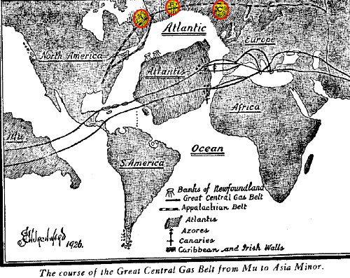
THE GREAT CENTRAL GAS BELT
On the map, page 109, I have shown The Great Central Gas Belt as it runs from Mu, the Motherland to Asia Minor.
After passing under Mu in two parallels or divisions, it proceeds in an easterly direction under the Pacific Ocean until it reaches Yucatan and Central America. Both divisions split up into parallels before passing under America. The Northern passes under Yucatan, the Southern under Guatemala and Honduras. From America they pass out under the West India Islands. Here the parallels close in together again and form two trunk lines.
The Northern division passes under the Atlantic Ocean to the Azores. There it splits into several parallels. Leaving the Azores these parallels pass on and enter Europe under Spain and Portugal. From the West India Islands the Southern division proceeds under the Atlantic until it reaches the Canary Islands, here it splits into parallels and enters Africa near Morocco, forming the Atlas Mountains.
The two divisions of the Great Central Belt were not forged at the same time, the Southern was formed later than the Northern.
Neither are they at the same depth from the surface of the earth. The Southern is thousands of feet further down in the bowels of the earth and possibly miles. This difference in their depth is confirmed by the fact that when Atlantis was first submerged she only went down deep enough to be awash at low tide so that at low tide mud banks appeared with masses of seaweed which made the Northern Atlantic Ocean impassable to shipping.
This fact is recorded in the temple histories of Egypt. It was only after the Southern division had been forged, which sank her to her present level, that ships could again cross the Atlantic.
Atlantis was in some respects in a similar position to Mu, both lands were being upheld above water by isolated gas chambers, both lay over the pathway of a forming belt. In both cases the isolated chambers were tapped by the forming belt and blown out, in both cases the land went down and was submerged, and, strange to say, the same belt was the double assassin.
From the fact that this great belt was formed where it is and the land above submerged we gather that there must have been a great depth of rock, free of chambers, between the chambers which helped to form the belt, and the isolated chambers which were upholding Atlantis and the Land of Mu. Had chambers existed between the belt chambers and the isolated ones above, these continental lands would have been submerged thousands of years before.
Had no isolated chambers been upholding Mu and Atlantis, there would have been a sufficient thickness of rock over the belt to have formed retaining angles when the gases escaped after uplifting the land.
Then these continents would not have been submerged; instead, mountain ranges would have been raised upon them.
From a geological standpoint there is no date shown when Atlantis was submerged except that it went down when the Great Central Gas Belt was formed under the North Atlantic Ocean. But what geology lacks, history provides and shows us that Atlantis first went down to awash 9500 B.C. and subsequently to where she lies today, Atlantis was a large continent and ultimately went down thousands of feet below the surface of the water. By her sinking an equally big hole was made in the waters in the center of the North Atlantic.
The surrounding waters flowed in to fill up this hole, which drew off the waters from surrounding shores and from all shallow parts because a new lower level to the ocean was formed. Somewhere about this time in the earth’s history the Appalachian-Iceland-Scandinavian Belt was formed. This belt commences in the Eastern Southern States, runs up through Labrador in Canada, from Labrador it passes under the Ocean to Greenland, Greenland to Iceland, and Iceland to Northern Europe, then to the Ural Mountains.
This belt has an immense number of ramifications.
The main belt is shown on the map as a broken line. Before this belt was formed there was no break in the land between America and Europe. They were connected by the submerged land shown in a shading and marked A, B and C.
This land is geologically known as “The Overland Route to Europe.” During the forging of this belt this land bridge was broken up and parts of it submerged.
The submergence of Atlantis and the “Overland Route” affected, by extension, the coast lines of Eastern America, Western Europe and Northwest Africa. The extension of these coast lines was due to the lowering of the level of the Atlantic Ocean, by taking the water to fill in the abysses made by the sinking of Atlantis and the Overland Route. Not only were the shore lines extended, but where the water was shallow it was drawn off and the land emerged.
Does geology confirm this statement?
It certainly does and as prominent examples I will call attention to:
- The elimination of the Amazonian Sea.
- The drying out of the Mississippi Valley.
- The drying out of the St. Lawrence Valley.
- The emerging of Florida, and
- The general extension of the Atlantic Coast Line of North America. At one time both the Mississippi Valley and the Valley of the St. Lawrence were shallow arms of the sea.
I have said that geology confirms my statements, so it does but in a reverse way. Poor old geology, it has ever been guilty of putting the cart before the horse. Geology is all right but only hitched up the wrong way.
Geology records,
“a general rise of the Atlantic Coast Line of North America during a recent period in the earth’s history, also similar phenomena on the West Coast of North America.”
Geologists have apparently based these opinions on the many marine beaches found inland in Eastern North America.
These have been geologically called Champlain beaches. In Europe similar phenomena are found. The geological Champlain Period is a part of the Pleistocene. It was during the Pleistocene that the gas belts were formed and mountains raised and the great submersions of land took place, many stretches of land emerging which had been in shallow water.
When geology states that the present elevations of the Champlain beaches are solely due to the raising of the land, geology is in error.
Their present positions are due to the work of two agencies: the first was the lowering of the level of the oceans, the second was volcanic workings elevating lands in the formation of the gas belt.
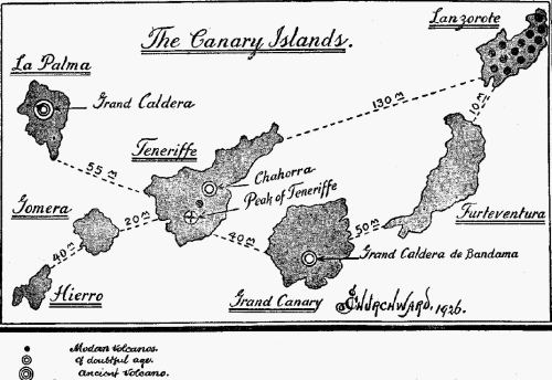
THE CANARY ISLANDS
The Canary Islands lie over the Southern Atlantic division of the Great Central Gas Belt.
They are situated off the northwest corner of Africa and distant from 60 to 120 miles. They are directly opposite where the belt goes in under Africa – Morocco.
The Canary Islands are of exceedingly great interest when looked upon from a volcanic standpoint. There are many volcanic craters on them, both ancient and modern.
By ancient, I mean they existed before the gas belts were formed and never had any connection with a gas belt.
Some of these ancient craters point directly to the submersion of Atlantis.
The volcano best known on the Canary Islands is the Peak of Teneriffe whose snow-capped head pierces the blue sky at an elevation of 12,000 feet. The ones, however, that are the most interesting to me are: the Grand Caldera, La Palma Island, and the Grand Caldera de Bandama, Grand Canary Island.
The Peak of Teneriffe is a modern volcano having been formed by the gas belt. One crater on Teneriffe Island is questionable – Chahorra. It has many earmarks of the ancient with just as many of the modern. I can find no record of its ever having been in eruption. La Palma Island lies between 50 and 60 miles northwest of Teneriffe, The crater on this island is called “the Grand Caldera.”
This crater is unquestionably an ancient one and has never been connected with any gas belt. It is the largest crater that I know of. Its diameter exceeds anything that is found among Pacific Islands. Ancient Kilauea, the monster on the Hawaiian Islands, measures three miles across its mouth while the mouth of the Grand Caldera is between four and five miles across.
The crater has a depth of between 6500 and 7000 feet. An examination of its sides discloses the fact that originally it was not of its present depth and the evidences tend to show that the drop from its original depth was not of a sudden character but took the form of a gradual subsidence. Personally, I believe that when the gases were exhausted and the sides fell together to seal it, the seal was loosely packed. Then time and subsequent earthquake shocks gradually packed and sank the surface to a lower level.
Being an ancient crater, one which was formed by the escaping gases from a gas chamber when overcompressed, it is, to my mind, one of the craters that helped to empty out the gases from under Atlantis and then submerge her, that the Island of La Palma was once a part of Atlantis.
The natives of La Palma Island relate a myth about the Grand Caldera and the Peak of Teneriffe which goes to show that La Palma Island was once a part of Atlantis.
The legend is:
“The Peak of Teneriffe was merely thrown up out of spite by the Grand Caldera during a most terrific volcanic upheaval.”
It does not take much thinking to see how this myth originated and the reason.
During the terrific volcanic workings during the formation of the gas belt running underneath these islands, the land which now forms the Peak of Teneriffe lay directly over the forming belt. Here was a line of least resistance. The Peak of Teneriffe was forced up and punctured, so the gases for the time being escaped.
The Grand Caldera being 40 to 50 miles away and in no communication with the forming belt remained inactive. On Grand Canary Island 40 miles to the southeast of Teneriffe there is another ancient crater, a small one only a mile across the mouth. It is called the Grand Caldera de Bandama.
All other craters on the Canary Islands are “modern,” all being connected with the gas belt.
THE AZORES
The Azore Islands in the North Atlantic Ocean lie directly west of Spain and Portugal.
The Northern division of the Great Central Gas Belt passes directly underneath them. As a matter of fact, the gas belt was the agent which emerged them. They are the tops of a submarine range of mountains that were raised above the water level. When Atlantis went down on the blow-out of the first gas chamber, this land was submerged. When the gas belt formed it raised this stretch of land into mountains, sending their tops above water level.
There is only one thing showing on the Azores that might possibly connect them with Atlantis: The Cavern Furna de Furnao Forge.
This cavern is the remains of an ancient crater that has been placed in another position from the original. What suggests itself to my mind is: this crater was one of many craters employed in emptying out the gases that were upholding Atlantis. When the roof fell it fell pretty flat around this area. Thus the crater would have maintained its original position vertical. (See Fig. I.)
Then when the belt was forming the gases found the least resistance to an uplift at d1.
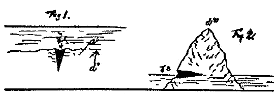
The surface a was raised to position d2, thus throwing the crater b1, Fig.1, from a vertical to a horizontal position b2, Fig. 2.
In this position it became a cavern, entered from the side of the hill. In giving this little geological sketch I have only touched the high points. A detailed account could be given which would naturally consume a lot of space.
What I have shown, however, seems to me that geology shows the one-time existence of Atlantis.
ATLANTIS AND ANTARCTICA
by Robertino Solàrion
Texas, 16 October 2000
Plato’s account of Atlantis in Timaeus and Critias is the original account of this “legend”, although later writers like Diodorus Siculus gave details about Atlantis. Since there is no reason for Plato to have deliberately lied about this, most traditional historians simply consider Plato’s tale to be allegorical in nature. But here, let us assume that it is true.
When was Atlantis destroyed and when did it “disappear beneath the sea”? Plato wrote about Solon’s visit to Egypt in 500 BCE, and he said that Atlantis had sunk beneath the sea approximately 9,000 years previously, leading us back to 9500 BCE. Others “round it off” to 10,000 BCE.
See also DOOMSDAY, THEN & NOW.
What did Atlantis look like? It was a round island continent with a high mountain range in the center and with the world’s largest natural harbor. Antarctica is a round island continent with a high mountain range in the center (the South Pole is at elevation 5,000 feet, something like that) and with the world’s largest natural harbor (namely, the Ross Sea).
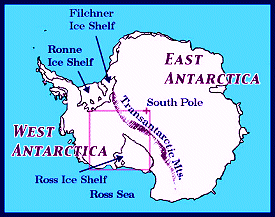
Where was Atlantis? The island continent was located at such a latitude on the planet to allow it to have a mild Mediterranean climate for most of the year, and it produced bountiful harvests of fruits and vegetables. If the Polar Axis were located in a different place, depending upon where Antarctica would be located, it could undoubtedly have had periods of excellent climate.
To reach Atlantis from Egypt, one had to sail out the Pillars of Hercules, that is, the Straits of Gibraltar. Note that the Suez Canal is a modern achievement; in bygone days, there was no maritime passage from the Mediterranean to the Red Sea. To reach Antarctica from Egypt in days when there was no Suez Canal, one would have had to sail out the Straits of Gibraltar and head southwards across the modern Middle and South Atlantic Oceans, assuming that one’s passage was not obstructed by Polar Ice.
Thus, these three crucial descriptive points that Plato made about Atlantis can lead us to the assumption that the unfrozen Antarctica, located at a Mediterranean-like northern latitude, was the legendary paradise of Atlantis. And this idea first occurred to me in 1973. Nothing that I have read or heard since then has contradicted this identification, and I’ll continue to believe it for the duration, until absolutely proven wrong.
Through the years, however, I have noticed certain other writers who mention this most logical identification, but because of the “mystical antiquity” of the whole idea, most people don’t pay much attention to any of it. It has become just another mythical bygone era of heroes and villains. And, for the record, it is not the place here to speculate about the “advanced technology” of Atlantis and its possible connections to Outer Space. Plato mentioned nothing about such advanced technology and space travel; those ideas were “channeled” later by people like Edgar Cayce — and thus they do not belong in historical or scientific discussions of this nature.
My “Theory Of Polar Axial Displacement” is complex in that there are so many details that have to be considered and coordinated. The following hypothesis is a summary of part, albeit a most important part, of the overall theory.
There is evidence of an “Ice Age” in South Africa and Hawaii. Traditional science assumes that the /current/ North and South Polar Ice Zones expanded towards the Equator; and traditionalists would conclude that the “Ice Age” in South Africa was a result of South Polar Expansion, and that of Hawaii of North Polar Expansion. There are all sorts of internal contradictions amongst the various establishment theories of so-called “Ice Ages”; Dr. Immanuel Velikovsky has adequately documented this.
These currently ice-free areas like South Africa where there is evidence of an “Ice Age” were merely under a different Polar Icecap at a different epoch of geological time. If you consult a world globe, you will have a better understanding of what I am saying.
If the cause of such Polar Axis Shifts is the periodic arrival, docking and tethering of the Planet Nibiru — Hyperborea, The Cosmic Tree, The Night Sun — then these catastrophes must repeat in cycles of 3,600 Earth Years, the length of one Nibiruan Year. The last one occurred in the year 1587 BCE, the traditional date for the Santorini Cataclysm and the Velikovskian date for the Exodus Catastrophe. The previous arrival occurred in the year 5187 BCE, which can be coordinated with the Floods of Noah, Utnapishtim and Deucalion.
And going back another 3,600 years prior to that takes us back to 8787 BCE for that arrival of the Planet Nibiru. Undoubtedly, the destruction of Atlantis, as recounted by Plato, coincided with that particular “crossing” of Nibiru, even though the calculated date here is not identical with Plato’s generalization of the date of 9500 BCE. But since these catastrophes are not caused by any other known periodic cosmic body, the conclusion is not far-fetched that the Atlantis cataclysm coincided with the 8787 arrival of Nibiru; the date 8787 is closer in time to 9500 than would be another whole period of 3,600 more years.
Dr. Velikovsky, it must be noted, did not believe in Plato’s literal date for the timeframe of Atlantis. He concluded that Plato meant 900 years, not 9,000 years, ago; and that the destruction of Santorini/Thera around 1600 BCE gave rise to the legend of Atlantis. This was picked up on later by Jacques Cousteau, and it has become the establishment retort to the antiquity date explicitly stated by Plato.
Assume that the North Pole was once located near Johannesburg, South Africa, and that the South Pole was located northeast of the Hawaiian Islands. This would completely reverse the north-south and east-west directions with respect to Egypt and the Great Pyramid. All of Africa would be a land mass stretching NORTH from Egypt towards the Johannesburg Pole, much like North America stretches northwards today to the Arctic.
The Pillars of Hercules, or Straits of Gibraltar, would have been east, not west, of Egypt and Greece (which itself would have been due-south not north of Egypt). And more importantly, the South Africa Polar Zone would not have obstructed maritime travel between the Mediterranean and the then-unfrozen Atlantis, which would have been located in the northern hemisphere at about the same latitudes as modern Australia is located south of the Equator, although twice as large as Australia. It would have had a wonderful Mediterranean-style climate and have been in total command of all the world’s major sea routes. This was PRIOR to 8787 BCE!
Then Nibiru returned, and the Poles shifted. The North Pole shifted from South Africa out into the middle of the South Atlantic Ocean, stretching from West Africa to northeastern Brazil, both regions of which contain evidence of an “Ice Age”. As a result of this shift of the Polar Axis, there was now North Polar Ice spanning the Middle Atlantic Ocean, blocking all maritime traffic between the Mediterranean and Antarctica/Atlantis via the Pillars of Hercules. Atlantis disappeared or “sank beneath the sea”. Contact between Egypt and Atlantis was severed permanently. Only the legend remained, to be handed down for thousands of years from priest to priest, until finally Plato recorded it for posterity.
With that introduction, here is the abstract from a lecture given by Flavio Barbiero at a June 1999 catastrophism conference at the University of Bergamo in Italy. Signor Barbiero lectured on the identification of Atlantis with Antarctica.
This abstract was included in the September 2000 edition (Volume V, Number 1) of “The Velikovskian” Journal published by Charles Ginenthal in Forest Hills, New York.
QUOTE
Was Atlantis In Antarctica? Arguments In Favor
By Flavio Barbiero,
Centro Camuno di Studi Preistorici
Capodiponte, Italia
All over the world there exist myths about a universal flood and traditions about an antediluvian civilization called Atlantis or Mu. Scientists deny usually any validity to such traditions or at least greatly reduce their significance, bringing them to more manageable spatial and temporal dimensions from an archaeological point of view (Santorini, etc.) Geology and archaeology, in fact, do not allow any space on Earth for an advanced civilization of the size and the antiquity of Atlantis, as described by Plato.
This attitude does not take into account the climatic situation on Earth during the concerned period. According to the theory exposed by the author [that is, Flavio Barbiero] in a previous section, the climatic situation during the Pleistocene was influenced by the fact that the North Pole was located between Greenland and Canada, at the edge of the great Wisconsin Icecap. As a consequence, the South Pole was placed near the current magnetic pole, on the coast of Antarctica facing Australia. The coast of Antarctica facing the Atlantic, therefore, was placed at a much lower latitude and was completely free of ice, as witnessed by conclusive geological evidence.
[COMMENT:Here we find that the Atlantic coast of modern Antarctica contains evidence of deglaciation, which is just what one might expect. It was the contention of Dr. Velikovsky that the previous North Polar Zone was centered between Greenland and Canada; thus, this is a Velikovskian idea. However, it is my thinking that the last North Pole actually was located a few hundred miles south of Greenland, more into the North Atlantic between Spain and Quebec. Nevertheless, the previous North Pole was located farther southwards into the Atlantic than today, in the direction of the former North Poles which were located in the Middle-South Atlantic Ocean and South Africa. RS]
While the palaeolithic cultures were thriving all over the remaining parts of the world, in that part of Antarctica the first human agricultural civilization developed in complete isolation, thanks to populations driven there by oceanic currents from Southeast Asia and South America.
At the end of the Pleistocene, an asteroid or a comet impact triggered a shift of the poles, according to the mechanism explained in the previous communication. This resulted in the worldwide catastrophe remembered by traditions as the “universal flood”, during which Atlantis sank (temporarily) in the ocean. Soon after, the glaciation covered the Atlantic coasts of Antarctica, thus deleting all archaeological evidence.
[COMMENT:From this statement, one can immediately note that this writer, as did Dr. Velikovsky, considers these occurrences as “random” events, such as an errant asteroid or comet. Thus, they are forced to discuss them in isolation from each other and thereby arrive at false conclusions. RS]
Several vessels must have survived the catastrophe, bringing their crew safely to the coasts of America, Africa and Asia. Here they started, in complete autonomy and isolation, the Neolithic cultures and later civilizations. The numerous striking similarities between ancient civilizations all over the world were due in our view to the common culture of the survivors of the flood. An impressive amount of evidence of different kinds supports this theory.
[COMMENT:Of course. Ignatius Donnelly inAtlantis : The Antediluvian Worldmentioned all of these similarities. They are the cornerstone of modern Atlantology. RS]
The chronological gap of 4 millennia between the end of Atlantis and the archaeological findings of the most ancient known civilizations (such as Mohenjo Daro, Ur and so on), is only apparent due to the thawing of the northern hemisphere’s icecap; the sea level has been constantly rising during the first 4 millennia after the end of the Pleistocene, for a total amount of possibly 130 meters, thus submerging any remnants of populations established along the coasts. This is confirmed by the existence of submerged structures all over the world, like the great pyramid off Yonaguny Island (Japan), the remnants of a town off the Cadiz coast and so on.
UNQUOTE
The following information was taken from an article by the late British Atlantologist, Dr. Egerton Sykes, that appeared in The Atlantis Magazine in September 1973 (page 95). “All three [Bimini, Andros, North Sea] are facets of the megalithic culture, which lasted until BC 1500 and which may well have started in BC 10,000 in Atlantis.
The ruins which we have been able to find are those which were on the European and American continental shelves which endured until BC 6000, the date when the Atlantic broke through into the Mediterranean by the Straits of Gibraltar, into the North Sea by Ys and Lyonysse; and into the Caribbean and surrounding islands of Bimini and Andros. The cause was probably the melting of glacial ice sheets in the North, the same as that which forced the Thalassic peoples to leave Central Asia.”
There were Polar Axis Shifts, with accompanying melting polar ice-caps, in 1587, 5187 and 8787 BCE. The fact that the “megalithic culture” lasted until about 1500 BCE undoubtedly reflects the axis shift of 1587; and the date for the Atlantic’s breaking through into the Mediterranean, along with other contemporaneous events, most certainly could be more accurately dated at 5187 BCE, rather than closer to 6000 BCE.
In the book Atlantis Rising by Brad Steiger (Dell, 1973) we find these observations. “In the January 1969 issue of Fate magazine, Hugh Auchincloss Brown reports on the evidence that indicates that the Temple of Serapis at Pozzuoli on the Adriatic Sea’s Gulf of Venice was erected by artisans of a civilization that existed 12,000 to 19,000 years ago.
Brown writes that the temple must have been erected when the site was above sea level, as it is at the present time, but that it has been below sea level by at least 20 feet, judging by the holes left by boring clams 15 to 20 feet above the present sea level. The creators of the great marble columns had tools that enabled their workmanship to rival the Egyptians’. According to Brown: ‘The present location of Pozzuoli is approximately 46° North Latitude, but at the time the Temple was erected its latitude was 40°. The earth did a roll-around which was caused by the eccentric rotating mass of ice at the North Pole, and Pozzuoli moved to approximately 65° North Latitude at which time the temple was submerged.'”
These conclusions of Mr. Brown confirm my own (as well as Dr. Immanuel Velikovsky’s) placement of the previous North Polar Zone in the North Atlantic Ocean and the zone previous to that in the upper South Atlantic Ocean. If this Temple of Serapis was constructed when its present geographical location was at about 40° North Latitude, then it must have been erected when the North Pole was located between Nigeria and Brazil. At that time the Gulf of Venice was located at about 35° North Latitude, rather than at its present latitude of 46° North.
Then following the Polar Axis Shift of 5187 BCE, when the Atlantic broke through the Straits of Gibraltar and thereby raised the level of the Mediterranean Sea, the site of the Temple of Serapis in the Gulf of Venice not only would have most likely been submerged but also would have been located at about 55° North Latitude. Thus, when the North Pole was positioned between Spain and Québec, south of Greenland, from 5187-1587 BCE, the level of the Mediterranean Sea must have been at least 20 feet higher than its present level.
This would also help explain recent enigmas discovered in the Black Sea. Finally, following the Polar Axis Shift of 1587 BCE, the level of the sea decreased and exposed the Temple of Serapis once again, now located at its current latitude.
Finally, here is additional miscellaneous information which is taken from the book We Are Not The First by Andrew Tomas (Bantam Books, 1971), pages 74-76. This information in included here for the record.
QUOTE
The people of antiquity believed in the tremendous ages of the world and mankind, which they estimated in tens of thousands and even millions of years. To the European of Napoleonic times, the earth and man were created by God only several thousand years ago. However, the Asiatics had different views.
The Brahmins of India calculated the duration of the universe, or the Day of Brahma, to be 4.32 billion years. The Druses of Lebanon set the beginning of creation at 3.43 billion years. The present age of the earth is considered to be about 4.6 billion years, whereas that of the crust is 3.3 billion years. There are strange parallels between these figures. What is really extraordinary is the pundits’ time reckoning in milliards of years — cosmic chronology of this type was unknown until this century.
According to Simplicius (sixth century A.D.) ancient Egyptians kept records of astronomical observations for 630,000 years. The archives of Babylon were 470,000 years old, wrote Cicero with a remark that he did not believe this claim. Hipparchus (c. 190-125 B.C.) mentioned Assyrian chronicles stretching back for 270,000 years.
The Egyptian priests told Herodotus [sic — actually it was Solon, whose visit was mentioned by Plato in Timaeus & Critias] in the fifth century B.C. that the sun had not always risen where it rose then. This implied that they had kept records of the precession of equinoxes, covering at least 26,000 years.
The Greek historian Diogenes Laertius (third century A.D.) claimed that the astronomical records of Egyptian priests began in 49,219 B.C. He also referred to their registers of 373 solar and 832 lunar eclipses, which would involve a period of approximately 10,000 years.
The Byzantine historian George Syncellus said that the chroniclers of the pharaohs had recorded all events for 36,525 years. Martianus Capella (fifth century A.D.) wrote that the Egyptian sages had secretly studied astronomy for over 40,000 years before they imparted their knowledge to the world.
The first dynasty after the Deluge was traced by Babylonian priests to a date 24,150 years before their time.
According to Codex Vaticanus A-3738, the Mayas had kept their calendrical system since 18,612 B.C.
Herodotus places the reign of Osiris at about 15,500 B.C. from the information given to him by the priests of the land of the Nile. He made the remark that they were quite certain about the exactitude of the date.
The lunar calendar of Babylon and the solar calendar of Egypt coincided in the year 11,542 B.C. The calendrical computations of India began with the year 11,652 B.C.
According to Plato, the Egyptian priests fixed the date of the sinking of Atlantis at 9850 B.C., while the Zoroastrian books set the “beginning of time” at 9600 B.C.
That these dates are correct can be questioned. But we cannot escape the conclusion that the ancients were much closer to the truth than the scholars and clerics of one and a half centuries ago who thought that the world had been created in 4004 B.C., according to the Biblical chronological study of Bishop Ussher.
The universe of the Brahmins was almost as old as that of modern science. The chronicles of the Mayas, the Egyptians, and the Babylonians went farther back in time than our history. In view of what our science has yet to learn, it would be presumptuous to accuse them of exaggeration.
The mental horizons of the peoples of antiquity were vast, and we are only beginning to see today what they perceived yesterday.
The priests of Babylon and Egypt believed that man was civilized 500,000 years ago. They kept historical and astronomical records in their archives, as Simplicius and Cicero tell us. We can smile at these claims and give civilization 5,000 years to progress from the chariot to the automobile, from bows and arrows to the atomic bomb, from the boat to the spaceship.
UNQUOTE
Since 1973, I have been a charter lifetime member of the Ancient Mediterranean Research Association headquartered in Los Angeles, California. Our Founder and Director is Professor Maxine Klein Asher, formerly of Pepperdine University. The Co-Founder was Pepperdine Professor Julian Nava, who later served as U.S. Ambassador to Mexico under President Jimmy Carter.
I first became acquainted with Dr. Asher in 1973, because she was in the news for her expedition to Spain to prove the discovery of the Lost Atlantis. Accompanied by Spanish undersea diver Francisco “Paco” Salazar Casero, she travelled with a university group to Cadiz. Paco, she reported later, took some underwater photos of Atlantean artifacts. But, as luck would have it, they were diving and exploring too close to a top-secret naval facility and got “chased out” of Spain as spies, fearing for their lives, and sought refuge in Ireland.
Back in New York City, Maxine gave a press conference, and she got stories written in Time, Newsweek and US News & World Report, as well as in various newspapers like The Dallas Morning News. 1973 was also the same year that I’d taken up the study of Atlantis myself, and I was most intrigued by her expedition. However, before I ever heard of her, I’d already made up my own mind that Atlantis was Antarctica, not some area only a short mile or two off the coast of Cadiz.
Paco’s pictures were blurry black-and-white images of a couple of “ancient” vases, supposedly on the bottom of the ocean. There was no size-frame of reference for anything, and no people were in these pictures. But other than these pictures and her own account of events as she chronicled in her book The Atlantis Conspiracy, over the years Dr. Asher has produced absolutely no evidence of Atlantis off/in Spain. And she has made over 40 trips to Spain in this regard.
She informed me several years ago that she has a lot of “confidential” material which she is unable to reveal to anyone, not even to trusted longtime association members like myself, who have contributed money to the funding of one of her illustrious expeditions to Cadiz and who were promised a full report which we investors never received. Frankly, I don’t buy it anymore. After all these years, as well as the fact that she herself is getting older, she should release some of this material to prove her contention. Periodically she will send out a newsletter from AMRA, faithfully I might add for 27 years. In it she will once again state that an exciting new discovery is about to be made in Atlantis research, so stay tuned for more details. After a while, it becomes repetitively old news.
Atlantis was Antarctica. Once whilst on a trip to Southern California, I visited Dr. Asher and was invited to lecture to the association. I took along my world polar globe and demonstrated how Plato could have been referring to Antarctica. Maxine and the group listened politely and applauded, but I got the distinct impression that I was merely their “curiosity program” of the month, that none of them intended to give up the fantasy belief that Atlantis was off the coast of Cadiz.
Again, her newsletter arrived today. She had the following to report about a recent television program which I personally did not see and knew nothing about.
QUOTE
The Search For AtlantisA&E Cable TV
September 10, 2000
A recent two-hour documentary about Atlantis was aired on A&E cable television, narrated by Ted Danson. Everyone who viewed the show thought it was a “nightmarish” collection of non-truths and omissions obviously designed to abort Atlantis research and keep the truth about the lost continent as a myth.
The show was hastily made and absolutely flawed. Here are some of the errors.
1) The show claimed that Plato made up his story about Atlantis because he was upset over the death of Socrates. There is absolutely no truth in this statement and it cannot be documented.
2) The documentary stated that Columbus was searching for Atlantis. This is untrue. Columbus was aware of Atlantis but his primary goal was to find new land for the Spanish crown.
3) That statement that if Atlantis exists, it is either in Bolivia or Antarctica (where it obviously is not). No mention was made of either Spain or Bimini where most Atlantis research has taken place. No mention was made of Dr. David Zink or the Cayce explorations at Bimini. Bimini was mentioned in one sentence, glossed over, and no photographs were displayed, even though ample film exists about this site.
4) The daughter of the deceased Greek archaeologist Marinatos was shown on camera, giving the wrong dates for Santorini (Thera) and claiming it was not Atlantis. No mention was made of Marinatos’ mentor, Dr. Angeles Galanopolous, a superb archaeologist, whose book in 1968 was irrefutable proof of the connection between Atlantis and Thera. Recent datings of Thera in “Archaeology” Magazine pre-date the statements made on the TV show by more than 3,000 years.
5) Both Edgar Cayce and Madame Helena Blavatsky were made to look like fools. Statements made about these two mystics were totally in error and very defamatory.
6) One-half hour was devoted to Hitler and his desire to turn Germany into Atlantis, using Atlantis as the reason for the Holocaust. We know that Hitler was intrigued by Atlantis but the causes of the Holocaust were complex and only marginally related to the Atlantis story.
There were other major errors and omissions. The show closed with a picture of the new Atlantis Hotel and Casino in the Bahamas showing a gambling table and hinting that this was probably what Atlantis was like.
Your editor appealed to A&E, to Ted Danson and to the two sponsors of the show, but no response was received.
UNQUOTE
By “other major errors and omissions” Dr. Asher is undoubtedly referring to the fact that A&E did not consult or interview her for this program. She’s been claiming for years that she is going to produce her own movie or television program about Atlantis and finally reveal all, but she’s never struck a deal with anybody despite her Hollywood connections.
She is a friend of actress-dancer Ann Miller, who was affiliated with this association at one time. Ann Miller accompanied Maxine to Cairo on an expedition to search for possible clues as to the location of the buried annals of Atlantis. They were wined and dined in style by the Mayor of Cairo and other notables, for the most part academics. They discovered nothing, but they sure did have a good time, sailing up and down the River Nile! As part of the trip, they invited flautist Paul Horn along.
He received permission from the Egyptian antiquities department to record some flute music inside the King’s and Queen’s Chambers of the Great Pyramid and the Second Pyramid. AMRA was partly behind the recording and marketing of this album. I have a copy (two-record volume), and it is some of the most breathtakingly beautiful music that I have ever heard.
The album set featured an insert, describing the expedition and the process of recording the music, in which Dr. Asher is shown photographed with Paul Horn at the Pyramid Complex. This album is probably no longer available. For your information, Paul Horn also recorded a live album in the Taj Mahal, which I have heard; but I think it pales compared to the acoustics of the Pyramids, where the internal echoes of the notes being played intermingle with the actual melody — it is fascinating music and so totally pleasing to the ear and relaxing to the mind! Everybody who had a hand in that Pyramid flute project should be complimented and congratulated.
As for item 3 above, Dr. David Zink wrote a book titled The Stones Of Atlantis describing his research concerning the Bimini Blocks, as well as linking Atlantis to legends of “Pleiadian Gods” which are prevalent in Central and South America. This is an excellent book, and I have a copy. There is/was another undersea explorer named J. Manson Valentine who conducted similar research from his base in Miami. He has also been affiliated with Maxine and AMRA in past years.
As for Edgar Cayce, he is ultimately only another “channeler”, nothing more nor less. His information must therefore be discounted, and it is surprising that Maxine continues to cite the Cayce Foundation. And one cannot even begin to put Cayce into the same intellectual category with Madame Blavatsky, if indeed that is what the program implied, as Maxine reported (see item 5).
Regarding item 4, I do not know what she is really referring to here. Her statements are confusing because she herself doesn’t believe that Atlantis was Santorini. Her statement about the dating of the Thera/Santorini Cataclysm is equally obscure; Santorini is definitively dated to about 1500-1600 BCE — there is no argument here at all from anyone.
In short, it is w-a-y over time for Dr. Maxine Asher to put up or shut up.